Tallai is a suburb in the City of Gold Coast, Queensland, Australia. In the 2021 census, Tallai had a population of 4,465 people.
Geography
Tallai is situated in the Gold Coast hinterland.
Demographics
In the 2011 census, the population of Tallai was 3,765 people, 51.8% female and 48.2% male. The median age of the Tallai population was 43 years, 6 years above the national median of 37. 65.8% of people living in Tallai were born in Australia. The other top responses for country of birth were England 8.3%, New Zealand 7.2%, South Africa 2.1%, Scotland 1.1%, Germany 0.7%. 86.9% of people spoke only English at home; the next most common languages were 1% German, 0.8% Italian, 0.6% French, 0.6% Japanese, 0.5% Spanish.
In the 2016 census, Tallai had a population of 4,150 people.
In the 2021 census, Tallai had a population of 4,465 people.
Education
There are no schools in Tallai. The nearest government primary schools are Mudgeeraba State School in neighbouring Mudgeeraba to the east, Mudgeeraba Creek State School in neighbouring Mudgeeraba to the south, and Gilston State School in neighbouring Gilston to the north-west. The nearest government secondary schools are Robina State High School in Robina to the east and Nerang State High School in Nerang to the north.
Amenities
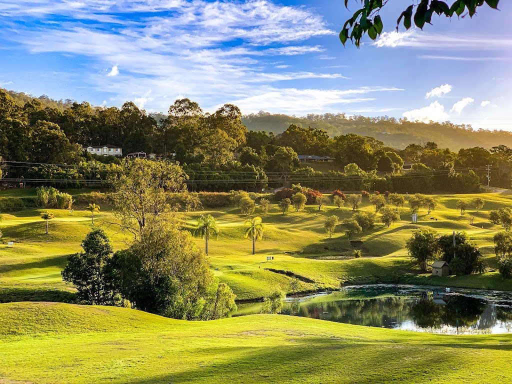
Tallai Country Golf Club has a 9-hole golf course at 22 The Panorama (28.0571°S 153.3285°E / -28.0571; 153.3285 (Tallai Country Golf Club)).
Mudgeeraba Lodge is an aged care facility at 21-25 Old Coach Road (28.0727°S 153.3525°E / -28.0727; 153.3525 (Mudgeeraba Lodge)).
Parks
There are a number of parks in the area:
- Frank Chaston Sporting Field (28.0409°S 153.3094°E / -28.0409; 153.3094 (Frank Chaston Sporting Field))
- Glenrowan Bush Reserve (28.0631°S 153.3174°E / -28.0631; 153.3174 (Glenrowan Bush Reserve))
- Grandview Terrace Parkland (28.0811°S 153.3273°E / -28.0811; 153.3273 (Grandview Terrace Parkland))
- Hinze Dam Catchment - Numinbah Forest Reserve (28.0823°S 153.2832°E / -28.0823; 153.2832 (Hinze Dam Catchment - Numinbah Forest Reserve))
- Imfeld Court Reserve (28.0630°S 153.3384°E / -28.0630; 153.3384 (Imfeld Court Reserve))
- Imfeld Court West Reserve (28.0621°S 153.3371°E / -28.0621; 153.3371 (Imfeld Court West Reserve))
- Ingles Park (28.0771°S 153.3489°E / -28.0771; 153.3489 (Ingles Park))
- Landlocked Park (28.0716°S 153.3271°E / -28.0716; 153.3271 (Landlocked Park))
- Liquidamber Court (28.0501°S 153.3171°E / -28.0501; 153.3171 (Liquidamber Court))
- Michael L Ring Park (28.0796°S 153.3444°E / -28.0796; 153.3444 (Michael L Ring Park))
- Muller Park (28.0452°S 153.3080°E / -28.0452; 153.3080 (Muller Park))
- Otiose Reserve (28.0775°S 153.3422°E / -28.0775; 153.3422 (Otiose Reserve))
- Range Road Reserve (28.0764°S 153.3198°E / -28.0764; 153.3198 (Range Road Reserve))
- Sid Bigg Park (28.0711°S 153.3520°E / -28.0711; 153.3520 (Sid Bigg Park))
- Smith Park (28.0677°S 153.3350°E / -28.0677; 153.3350 (Smith Park))
- Tallai Rd Reserve (28.0753°S 153.3249°E / -28.0753; 153.3249 (Tallai Rd Reserve))
- Tallai Road South Reserve (28.0778°S 153.3263°E / -28.0778; 153.3263 (Tallai Road South Reserve))
- Viscount Road Reserves (28.0713°S 153.3387°E / -28.0713; 153.3387 (Viscount Road Reserves))
References
External links
- "Worongary and Tallai". Queensland Places. Centre for the Government of Queensland, University of Queensland.